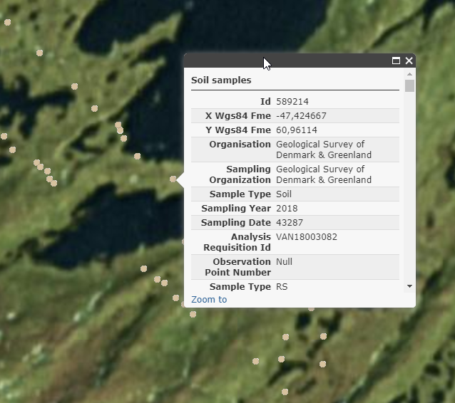
UpDeep Online Statistics Tool data is stored in a file geodatabase by ESRI. There are two feature classes or tables in the DB at this moment. Plant data is stored in the Plants table and the Soil table is for storing soil data. Data in the DB tables contains metadata (including field data) and laboratory analysis data. Metadata in this case means shared columns for both tables like information about organization, sampling organization, sample type (soil, plant), sample type code (RS, LD, AD, LLD, SRM, PRM), sampling year and date. At this time only Routine samples (RS) are used in this web application. Location based information like country, municipality, site and coordinates of the sample point is also stored in the database. Database is using WGS 84 (EPSG:4326) as the coordinate system. There is also possibility to store information about commodity elements, mineralization size, geological deposit type and deposit depth in the location of the sample point in the field.
For a collected plant sample the DB contains information on the plant name and organ (i.e. tissue type) of the plant, plant pre ashed and ashed weight.
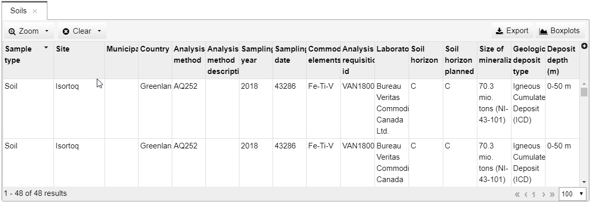
The soil table has columns for soil depth, soil sediment type, soil horizon and soil pH. Also soil sieved size (particle size) and drying time and temperature have their own DB columns.
Both DB tables also contain data related to the laboratory analysis such as sample id, laboratory id, analytical information like used laboratory, analysis method, analysis data, name of the project and standard reference sample used to monitor laboratory quality. Data of the elemental concentration levels is stored to four different columns: The first of these columns tells the concentration level, the second is the quality code for an element (<,>) and the third and the fourth columns are used for lower (LDL) and upper detection limits (UDL).
The map application is heavily based on spatial information. Thus it is important that every laboratory analysis of RS and FD samples have their geographical location (coordinates) fed into the DB by the data provider.
| Attribute name | Description |
| ID | |
| Prep method | Preparation method |
| Element | Element |
| Unit | Unit |
| LDL | Lower detection limit |
| UDL | Upper detection limit |
| X_WGS84 | X coordinate in the WGS84 coordinate system with decimals |
| Y_WGS84 | Y coordinate in the WGS84 coordinate system with decimals |
| ORGANIZATION | Name of the company holding the exploration permit for the sampling site at the time of sampling |
| SAMPLING ORGANIZATION | Name of the company fully/partially responsible of the sampling |
| SAMPLE_TYPE | Sample type (Soil, Plant) |
| SAMPLING_YEAR | Year when sampling was conducted |
| SAMPLING_DATE | Date when sampling was conducted |
| ANALYSIS_REQUISITION_ID | Analysis requisition identifier used to identify the batch of samples sent to the lab at one instance and prepared/analysed with same specifications |
| OBSERVATION_POINT_NUMBER | Identifying mark of a sampling location |
| SAMPLE_TYPE_CODE | Sample type code (RS = routine sample, LD = laboratory dublicate, AD = analytical dublicate, LLD = laboratory dublicate inserted by the laboratory, SRM = standard reference material, PRM = project reference material) |
| LAB_ANALYTICAL_DUPLICATE | SAMPLE_ID of thr laboratory dublicate pair |
| LAB_LABORATORY_DUPLICATE | SAMPLE_ID of the laboratory inserted laboratory dublicate pair |
| FIELD_DUPLICATE SAMPLE_ID | SAMPLE_ID of the field dublicate pair |
| SAMPLE_ID | A unique identifier for a sample |
| PROJECT_REFERENCE_MATERIAL_NAME | Name of the project referense sample used to monitor laboratory quality (PRM) |
| STANDARD_REFERENCE_MATERIAL_NAME | Name of the standard referense sample used to monitor laboratory quality (SRM) |
| AANALYSIS_DATE | ANALYSIS_DATE |
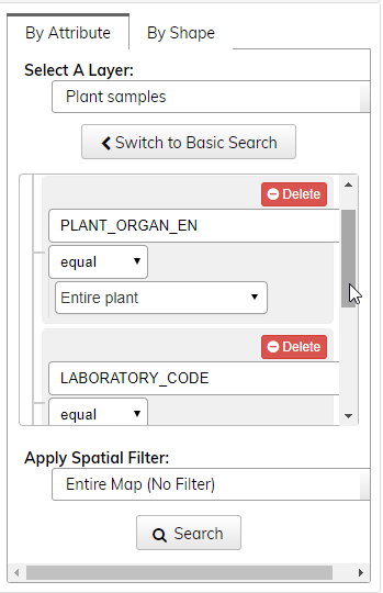
| LABORATORY_CODE | Laboratory method used |
| ANALYSIS_METHOD_DESCRIPTION | Explanation of the laboratory method code used |
| LABORATORY | Name of the laboratory conducting the laboratory analytics |
| SITE | Name of the sampling site |
| MUNICIPALITY | Name of the administrational region where the study site is located |
| COUNTRY | Name of the country where the study site is located |
| COMMODITY_ELEMENTS | List of the primary commodity elements of a deposit/occurence explaining of the underlying mineralization |
| MINERALIZATION | Location of the sampling point in relation to a known mineralization verified by drilling (0 = no known sampling location lying under the sampling location, 1 = a mineralization verified by drilling under the sampling location, depth indicated in DEPOSIT_DEPTH) |
| SIZE_MINERALIZATION | very large deposit, large deposit, madium size deposit, small deposit, occurance or NA according to the most importantly ranked commodity, https://inspire.ec.europa.eu/documents/Data_Specifications/INSPIRE_DataSpecification_MR_v3.0rc3.pdf |
| GEOL_DEPOSIT_TYPE | Geological deposit type used only if underlying mineralization is verified by drilling |
| DEPOSIT_DEPTH | Minimum and maximum depth of a drilled/modelled mineralization from the ground surface in meters (e.g. 100-200) |
| PLANT_PRE_ASHED_WEIGHT_GRAM | Plant sample weight (g) before ashing. [Plant samples only] |
| PLANT_PRE_ASHED_WEIGHT_MDL | Minimum detection limit for plant material weighting (g) before ashing. [Plant samples only] |
| PLANT_ASHED_WEIGHT_GRAM | Weight of an ashed plant sample (g), after ashing. [Plant samples only] |
| PLANT_ASHED_WEIGHT_MDL | Minimum detection limit for plant material weighting (g). [Plant samples only] |
| PLANT_SPECIES_EN | Plant species in english. [Plant samples only] |
| PLANT_SPECIES_LAT | Plant species in latin. [Plant samples only] |
| PLANT_ORGAN_EN | Plant organ type in english. (entire plant, twig/stem, leaf/needle, bark, wood/tree ring, root, resin, sap, gas, transpired fluid) [Plant samples only] |
| SOIL_START_DEPTH_METER | Sampling start distance from soil surface downwards in meters. [Soil samples only] |
| SOIL_END_DEPTH_METER | Sampling end distance from soil surface downwards in meters. [Soil samples only] |
| SOIL_SEDIMENT_TYPE_EN | Soil sediment type in english (Till, Humus) [Soil samples only] |
| SOIL_HORIZON | Sampled soil horizon (A, B, BC, C, Humus) [Soil samples only] |
| SOIL_HORIZON_PLANNED | Planned soil horizon (A, AB, Ah, B, C) for sampling. [Soil samples only] |
| SOIL_PH_WATER | pH value measured from soil-water (1:2) mixture. [Soil samples only] |
| SOIL_PH_VINEGAR | pH value measured from soil-water mixture after 20 sec of adding a drop of vinegar. [Soil samples only] |
| SOIL_SIEVED_GRAIN_SIZE_MESH | Sieve size (in mesh) used to sieve the soil sample. [Soil samples only] |
| SOIL_SIEVED_GRAIN_SIZE_MM | Sieve size (in mm) used to sieve the soil sample. [Soil samples only] |
| SOIL_DRYING_TEMPERATURE | Temperature (in Celcius degrees) used to dry the soil sample in an oven. [Soil samples only] |
| SOIL_DRYING_TIME | Soil sample drying time (minutes) used to dry the soil sample in an oven. [Soil samples only] |