Maapeli and Kapalo mobile
What?
This is helpfile describing the common tasks for capturing geological field data with Kapalo and Maapeli mobile.
Copyright 2015 Geological survey of Finland/Tero Rönkkö
This helpfile is being hosted at: http://gtkdata.gtk.fi/mobiili/index.html.
Tämä ohje löytyy suomenkielisenä osoitteessa: http://gtkdata.gtk.fi/mobiili/index_fin.html.
Where to get?
Kapalo

Maapeli

Geological content
Geological content documentation for Kapalo in english can be found here Mobiilikapalo-ohjeistus_ENG.pdf
MobiiliKapalon geologisen sisällön ohjeistus löytyy tästä Mobiilikapalo-ohjeistus.pdf
Symbology for rock types here
Domain values and their descriptions here
Language
Kapalo is available as Finnish and English versions. If the operating language in in Finnish, also the program will be in Finnish. With all other languages the program will be in English.Maapeli is currently available only as Finnish version.
Database
Database for the current versions of Kapalo and Maapeli is stored in the work folder of the application, you cannot directly access it.
To get a backup copy or copy to be worked with on your PC click open menu from the upper rigth hand corner in the map view and click "Export name_of_aplication.sqlite database file", then select name and location of the copy to be created.
You are also asked if the observation photos should be copied to DCIM folder of the device
In older versions of Kapalo (=>1.6.2 / May 2021) and Maapeli the database is stored in the root folder of the used device with name "name_of_aplication.sqlite".
Photos
Application can directly use the camera of the device if the observation photos are taken by clicking the camera symbol on the observation photo point. Photos are stored in the working folder of the application and are not directly accessible with file manager. You can copy them "visible"
at the same time when you make a backup copy of the database. I.e. by selecting "Export name_of_aplication.sqlite database file" from the menu in the upper rigth hand corner in the map view. The application asks if new photos associated with observations are to be copied into DCIM folder of the device.
Overview of user interface
Maapeli and Kapalo mobile are tools for collecting geological field data on the go. They are designed to run on Android 4.4.2 and above.
Components on the app are action bar, map and individual edit pages for dataitems.
Actionbar

Action bar contains the buttons for interacting with map and observation database.
Settings

Opens up settings page. Different settings are explained in more detail under Settings -section.
Edit

Edit last observation created in the database.
Create point

Create new observation at the detected current gps coordinates. This item is disabled until there is GPS lock.
Locate / Center map

Center the map on currently detected GPS coordinates. This item is disabled until there is GPS lock.
Choose layers
If multiple map layers are available, choose which to show.
Browse items

Opens browse items - form. This form gives you quick overview of all items in the database. You can edit and focus on the items on the list.
Open menu
Opens up hidden items in the action bar. The items include:
-Help
-Export kapalo.sqlite/maapeli.sqlite database file (Creates a copy of the observation database in location selected by user, asks if the observation photos should be copied to DCIM folder of the device)
-Import offline-map file (Takes an offline map stored on the device into use)
-Remove offline map (Removes the offline map from the list)
-Clear database (Empties the database)
-About
-Exit
Working with the map
Controls
Pinch to zoom
Touch to pan
Touch and hold
Background map
You can choose between global ESRI online topographical basemap and Finnish national landsurvey basemap as online basemaplayer in the settings.
Custom offline maps
You can use custom offline .TPK tilepackage maps or geotiff images.
In Kapalo and Maapeli versions 1.6.2 and newer, you have to load them to device and install them by opening the menu from the upper right hand corner and selecting "Import offline-map file", this will move the file to the software's own work folder.
In Kapalo and Maapeli versions older than 1.6.2, copy the maps to the root folder of the device you're using
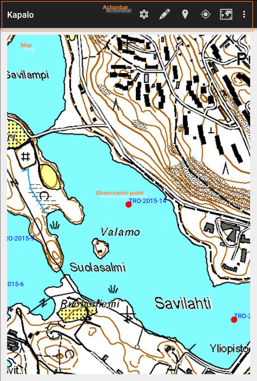
Browsing data
By selecting Browse items action in actionbar you can open up form to overview and manage all available items in the database.
Browse items -action icon
Browse items -form
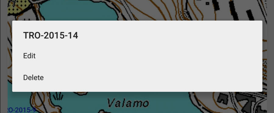
You can start editing on any of the items on the list by simply clicking on it. To focus the map on or delete the item, long press chosen item for a moment.
Editing data
Working with the details of the data is done through edit pages.
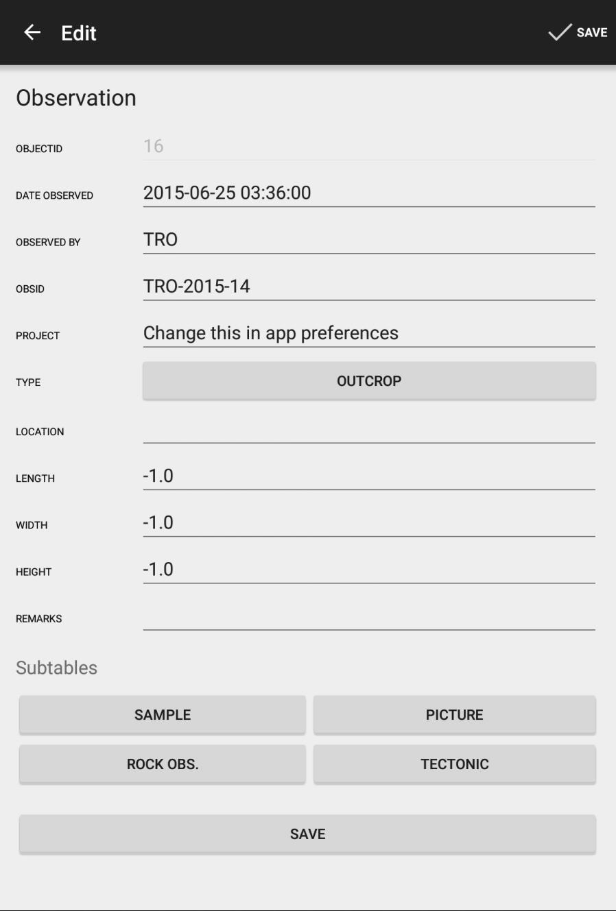
Field controls
There
Readonly field

Readonly field has uneditable edit part which shows as grayed out in this picture.
Text fields

Text fields can be either numeric or text fields.
Domain fields

Some fields accept values only from certain array of coded values (domains). Pushing the button opens up list of valid values.
User can modify the default domain lists. Instructions how it is done and e.g. alternative rock name list can be downloaded from here.
Subtables
Related data can be managed through subtables section on the edit page.
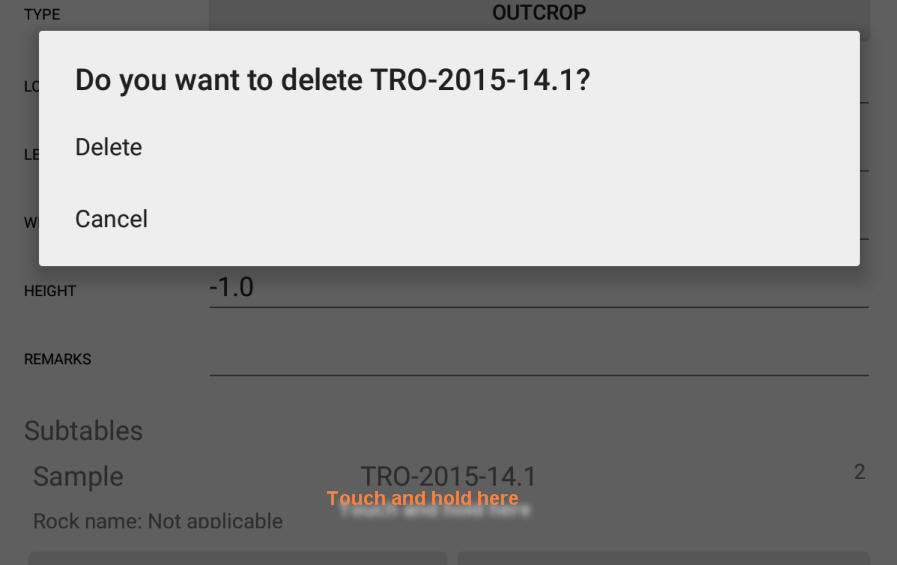
Deleting subtables
You can delete subtable rows from the master row by touch and holding on the subtable item list
Settings
You can find the settings button on the action bar on top of the application
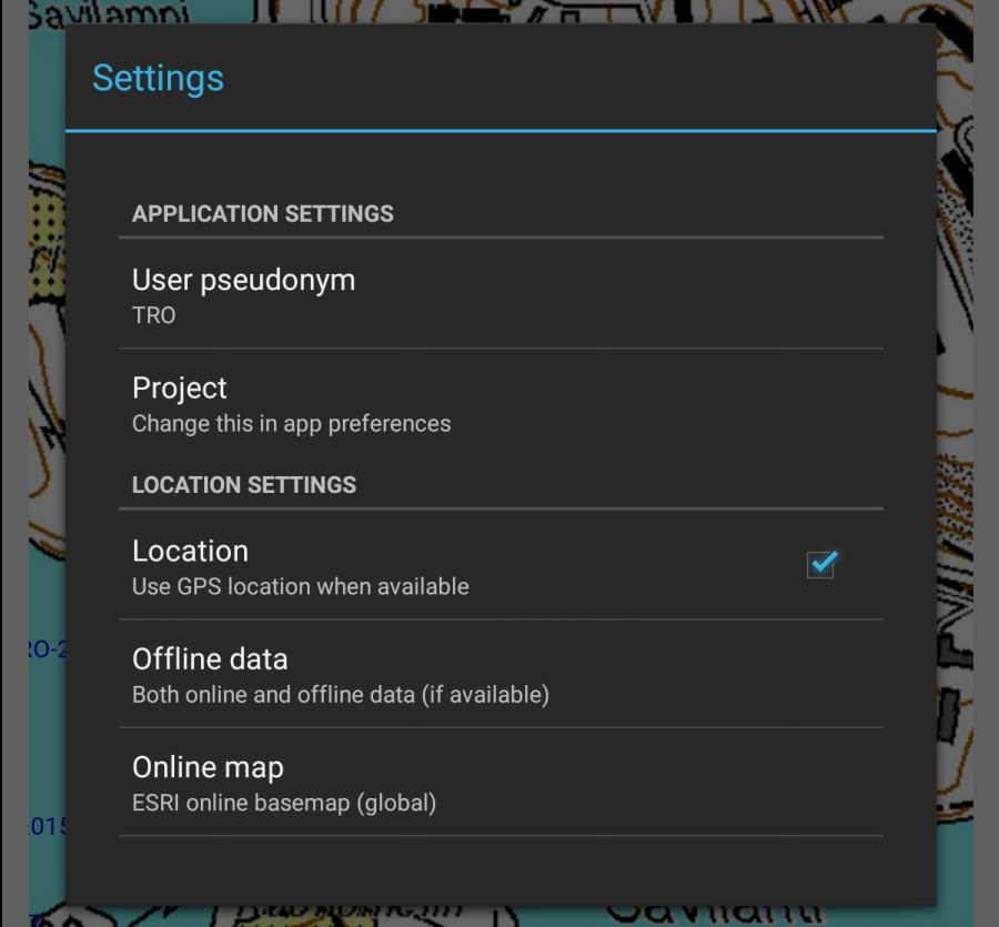
User pseudonym
Project
Location
Offline data
- Only online data - Use solely online maps
- Both online and offline data (if available) - Use local data to supplement online data
- Exclusively use offline data - Do not try to load online data at all. Use only local TPK and geotiff files.
Online map
- ESRI online basemap (global) - ESRI's default, global topological map
- Kapsi/NLS tilemapservice (Finland) - National land survey tilemap dataset hosted by Kapsi
Kapalo
Database tables for Kapalo are described and explained in this document: kapalodesc.html.
Geological content documentation for Kapalo in english can be found here Mobiilikapalo-ohjeistus_eng.pdf
Kapalo sovelluksen geologisen sisällön ohjeistus löytyy tästä Mobiilikapalo-ohjeistus.pdf
Mobsu
Users outside GTK can upload the installation kit from here: Mobsu installation.
Internal users of GTK can install the program from the Software Center.
As Mobsu uses ArcMap tools in the transfer, its use requires an ArcMap-license.
Installation kit also includes instructions for use of the ArcMap database and symbology files (.lyr)
The kit includes four versions of the ArcMap database for Kapalo
-Finnish domains and EUREF coordinate system
-Finnish domains and WGS84 coordinate system
-English domains and EUREF coordinate system
-English domains and WGS84 coordinate system
Maapeli database is only available in Finnish and EUREF coordinate system Note these two things
In the ArcMap database the structure is "unabridged". This means that it includes fields and layers that are not included in the mobile version of Kapalo.
In databases with English domains only those used by Mobiilikapalo are translated. Content of these translated domains is 1:1 with mobile version.
About
Kapalo and Maapeli mobile by Tero Rönkkö, maintenance and support by Sakari Hautala / Geological survey of Finland 2015
Mapping API provided by ESRI ArcGIS runtime SDK for Android
Online map data provided by ESRI, i-cubed, GeoEye, Kapsi / National land surveyof Finland (contains data released 05/2015)